No Photo
Property Record
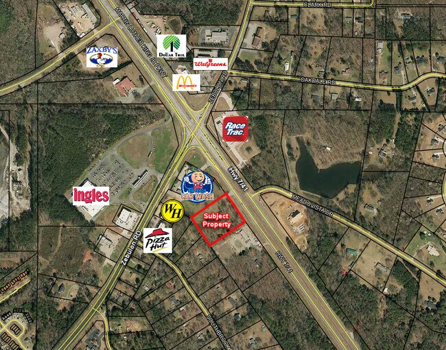
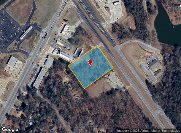
1722 Highway 7/41, Griffin, GA 30224
This Property Is For Sale
NEARBY LISTINGS FOR SALE OR LEASE
Property Detail
1722 Highway 7/41
233-05-013-L
PB 26/217 2.80 AC
Commercialacreage
Spalding
X
Georgia
13255C0185D
2.80 AC
2024
Spalding County
2024
Atlanta
161202
Atlanta-Sandy Springs-Roswell, GA
DEMOGRAPHICS near 1722 Highway 7/41
1 Mile
3 Mile
5 Mile
2024 Total Population
1,339
13,975
39,477
2029 Population
1,421
14,917
42,304
Pop Growth 2024-2029
+ 6.12%
+ 6.74%
+ 7.16%
Average Age
40
40
39
2024 Total Households
508
5,282
14,830
HH Growth 2024-2029
+ 6.10%
+ 6.55%
+ 6.99%
Median Household Inc
$68,668
$64,410
$52,198
Avg Household Size
2.60
2.60
2.60
2024 Avg HH Vehicles
2.00
2.00
2.00
Median Home Value
$202,158
$209,805
$193,364
Median Year Built
1976
1984
1979
Nearby Places
Map Layers
Map Styles
 Street
 Aerial
- Restaurants
- Banks
- Shops
- Fitness
- Groceries
Nearby Properties
Address
Land Use
TOTAL SIZE
Lot Size
Zoning
Address
Land Use
TOTAL SIZE
Lot Size
Zoning
46,074 SF
30.36 AC
OI
Address
Land Use
TOTAL SIZE
Lot Size
Zoning
16,394 SF
24.32 AC
LDRB
Address
Land Use
TOTAL SIZE
Lot Size
Zoning
99,469 SF
12.51 AC
AR-1
Address
Land Use
TOTAL SIZE
Lot Size
Zoning
2,374 SF
38.28 AC
HDRB
Address
Land Use
TOTAL SIZE
Lot Size
Zoning
31,328 SF
58.43 AC
PID
Address
Land Use
TOTAL SIZE
Lot Size
Zoning
31,328 SF
58.43 AC
PID
Address
Land Use
TOTAL SIZE
Lot Size
Zoning
16 AC
PCD
Address
Land Use
TOTAL SIZE
Lot Size
Zoning
74,910 SF
25 AC
AR-1
Address
Land Use
TOTAL SIZE
Lot Size
Zoning
65,058 SF
3.74 AC
Address
Land Use
TOTAL SIZE
Lot Size
Zoning
43,440 SF
23.20 AC
AR-1
Address
Land Use
TOTAL SIZE
Lot Size
Zoning
3,069 SF
15 AC
HDR-B
Address
Land Use
TOTAL SIZE
Lot Size
Zoning
41,194 SF
25.19 AC
C-1
Address
Land Use
TOTAL SIZE
Lot Size
Zoning
14,680 SF
1.89 AC
PCD
Address
Land Use
TOTAL SIZE
Lot Size
Zoning
3,716 SF
12.03 AC
PRD
Address
Land Use
TOTAL SIZE
Lot Size
Zoning
21,352 SF
0.74 AC
PCD
Address
Land Use
TOTAL SIZE
Lot Size
Zoning
56,516 SF
28.30 AC
C1
Address
Land Use
TOTAL SIZE
Lot Size
Zoning
39,777 SF
10.23 AC
INST
Address
Land Use
TOTAL SIZE
Lot Size
Zoning
5,640 SF
86.60 AC
C2
Address
Land Use
TOTAL SIZE
Lot Size
Zoning
99,088 SF
25.64 AC
PID
Address
Land Use
TOTAL SIZE
Lot Size
Zoning
22,158 SF
3.52 AC
C2
Address
Land Use
TOTAL SIZE
Lot Size
Zoning
20,510 SF
42.32 AC
Address
Land Use
TOTAL SIZE
Lot Size
Zoning
62,250 SF
10.17 AC
Address
Land Use
TOTAL SIZE
Lot Size
Zoning
1,537 SF
7 AC
HDRA
Address
Land Use
TOTAL SIZE
Lot Size
Zoning
2,400 SF
5.18 AC
C-1B
Address
Land Use
TOTAL SIZE
Lot Size
Zoning
14,732 SF
1.74 AC
C1
Address
Land Use
TOTAL SIZE
Lot Size
Zoning
59,524 SF
12.04 AC
PCD
Address
Land Use
TOTAL SIZE
Lot Size
Zoning
46,208 SF
5.79 AC
HDR-B
Address
Land Use
TOTAL SIZE
Lot Size
Zoning
6,904 SF
0.91 AC
PCD
Address
Land Use
TOTAL SIZE
Lot Size
Zoning
19,600 SF
5.03 AC
PID
Address
Land Use
TOTAL SIZE
Lot Size
Zoning
11,972 SF
0.42 AC
PCD
The World's #1 Commercial Real Estate Marketplace
Connect with us
© 2025 CoStar Group
The information above has been obtained from sources believed reliable. While we do not doubt its accuracy we have not verified it and make no guarantee, warranty or representation about it. It is your responsibility to independently confirm its accuracy and completeness. Any projections, opinions, assumptions, or estimates used are for example only and do not represent the current or future performance of the property. The value of this transaction to you depends on tax and other factors which should be evaluated by your tax, financial, and legal advisors. You and your advisors should conduct a careful, independent investigation of the property to determine to your satisfaction the suitability of the property for your needs.